Just got a shipment of Garmin Oregons in stock. As is customary with new-fangled Garmin stuff I always open one for myself.... so why not write a review?.. Several months ago Garmin came out with the Colorado series of handhld GPS's. These incorporated Garmin's sleek new look, pre-loaded charts, and a bunch of cool new features like wireless data sharing, magnetic compass, altimeter, and much more. Of course I had to have one of them. But when I caught wind of the new Oregon coming down the pipeline I couldn't sell my Colorado fast enough! The new Oregon is everything the Colorado is plus its Touchscreen! Having been a junky of other Garmin touchscreen products (Nuvi Automotive GPS, 5000 Series Boat GPS) for the last 2 years I couldn't resist. Here is what I've found so far:
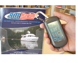
Form Factor - the unit has a 3" color touchscreen. It easily fits in, and can be manipulated, with one hand. In fact I have found operation to be easiest with one hand. The screen has the same typical brightness as other Garmin handhelds. Not spectacular but hardly shabby. The screen is not affected by Polarized Glasses as many of these screens are when rotated. The unit comes with a nice Caribiner clip to attach it to a belt loop or whatever. The clip is removable. The bottom of the unit has a rubber flap to protect the USB port. Inside the unit (when the batteries are removed) there is room for a Micro SD card.
Interface - This is where Garmin does things so well - they make it easy. The touchscreen is incredibly intuitive and easy to operate. For example, the databoxes in the upper corners of the chart screen - to change what they display just click on the box and make your selection. To scroll around the Map just drag your finger across the screen. To move around the menu just swipe your finger across the screen like an iPhone. It really is awesome. With a touchscreen unit only the buttons that actually do anything at any given time are visible, so it makes knowing what to click at any given time quite intuitive.
Features - The feature set is through the roof for this thing. I honestly don't know what they are going to think of next that this unit can't already do. I'll keep this review boating related, but for the non boaters it does geocaching, topo maps, automotive routing, fitness stuff and more. Changing between modes, or "profiles" as Garmin calls it, is super easy and can be done with a couple of screen taps. Back to boating... I have put the unit through its paces for typical use on a boat - making waypoints, doing routes, finding local info like Marina locations, and navigating on a chart. It does all of this wonderfully well. Scrolling around on the screen is done by dragging across the screen with your fingertip. Zooming is done by the transparent + and - button. Every screen has a little X or back arrow on the bottom left to move to the previous page or menu. Making waypoints is simple. Just tap on the screen where you want it, then confirm it as a waypoint. Once you save the waypoint you can edit it. The edit features are extensive - you can change name, symbol, depth, comments and more. While editing text a keyboard pops up with the whole alphabet, so editing a name or comments takes seconds.Routing is nice and easy too. You simply tap on "Routes" and either select a current route or build a new one. Building a new one requires the various waypoints to already be designated, then you pick among those waypoints to build the route. All very intuitive.Garmin's "Where To" feature now makes an appearance on this unit. This feature has been very popular on the auto and larger marine units. Basically, after tapping the "Where To" button you can choose a route, or choose a waypoint, or choose a point of interest like a Marina. Once selected the unit will make that the active route or destination.
Compass - This unit actually has a built in compass. Don't even ask me how it works, but its pretty damn cool. You hold the unit level while in Compass mode and a magnetic compass actually appears and finds North. Awesome little piece of redundancy.
Tides - the Oregon has Tide Data built in for the whole USA, as well as Sunrise and Sunset, and Moon Phases. I could go on and on about other "cool" features as it has plenty. One I found especially cool though is the "area calculation" tool. With this tool you basically stand at the edge of a section of land you want to measure, hit the "start" button then walk the perimeter of the land. Once back to your original position you hit the "Calculate" button and it will spit out the total acres. I did it on my backyard and got .445 Acres. Pretty neat.In my opinion this GPS has raised the bar. Garmin has done it again. I would highly recommend it to anybody looking for a handheld.
P/N 010-00697-03
Price - $599.99
BUY NOW
Main Menu in "Fitness Mode"

Area Calculation Tool

Points of Interest Format

Huge selection of waypoint symbols - this is just one of many pages!

Chart with active route

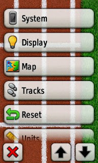
System "Setup" Menu
My backyard


Main Menu in "Marine" Mode


 Linear Mode

